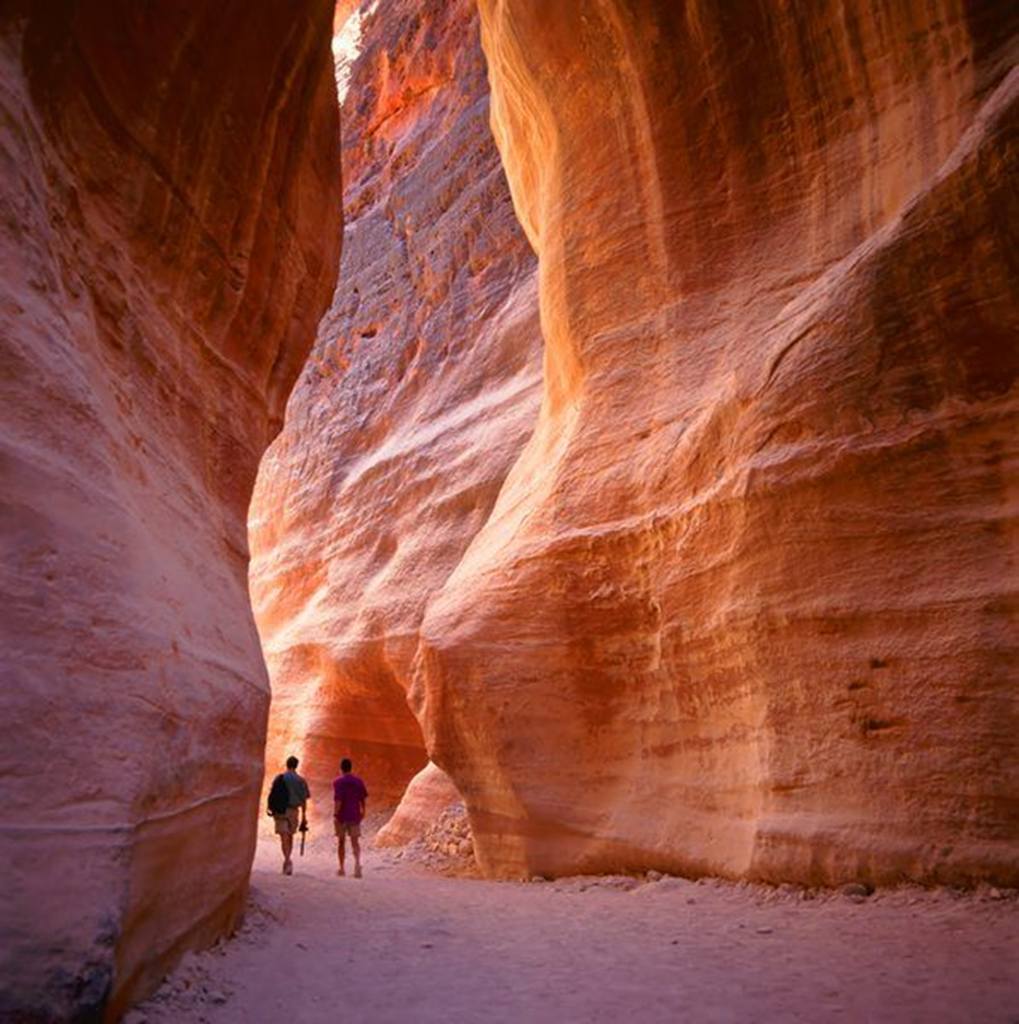
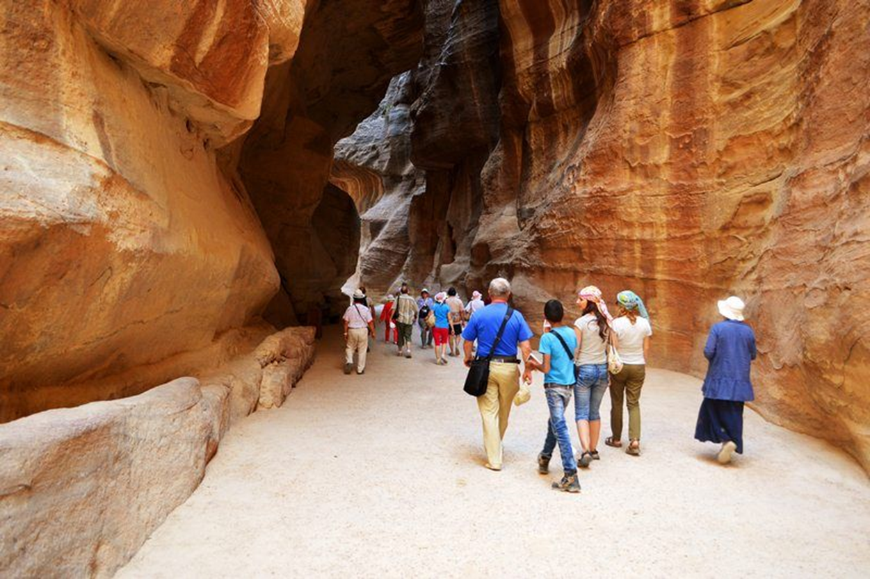
Con este nombre, o Siq, se conoce el impresionante acceso a la ciudad de Petra. Se extiende por algo más de un kilómetro, siendo bastante estrecho, con puntos de unos tres metros de ancho, y con una altura de entre 90 y algo más de 150 metros de altura. Es una falla natural que se originó por fuerzas tectónicas, siendo posteriormente erosionado por el agua.
La entrada del desfiladero contiene una presa que fue realizada para desviar la desembocadura del río y las aguas cercanas.
En el umbral se encontraba un arco monumental del que solamente quedan algunos vestigios. A lo largo de las paredes se localizan diversos nichos excavados con betilos, piedras sagradas, lo que dota al lugar de sacralidad. Asimismo, se hallan otras cámaras subterráneas de las que se desconoce la utilidad, aunque se cree que pudieron contener algunas tumbas. Se pueden ver algunos restos, mal conservados, de estatuas en la parte superior del desfiladero.
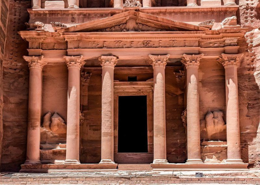
El nombre de tesoro deriva de la creencia de los beduinos que en su interior se escondía una fortuna que habían escondido los piratas. Otros piensan que eran los otomanos quienes pensaban que los beduinos habían ocultado riquezas en su interior. Sea como fuere, las tradiciones marcaban el sitio como extraordinario, incógnito e importante y de ahí esa creencia de la existencia de un tesoro.
Cómo es el monumento
Este edificio consta de uno 40 metros de altura por unos 28 de ancho. Lo más destacable del mismo es su fachada íntegramente tallada en la roca. Presenta un color rosado por el efecto de la oxidación sobre las rocas.
Cuenta con dos niveles. La parte inferior tiene unos doce metros de altura. Se compone de seis columnas con un frontón, con diversos relieves escultóricos, que no se encuentran bien conservados.
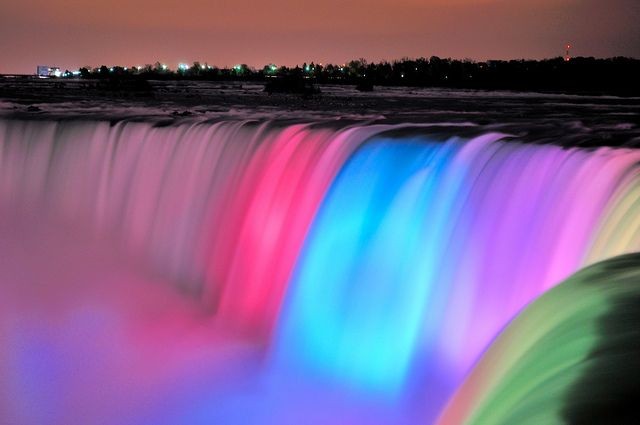
Frases celebres y significativas de la vida que vivimos en cualquier momento aun si estamos viviendo en mis lugares mágicos como los llamo y a los que visito para alejarme de la tristeza de la vida!!
Sedona is located in the Upper Sonoran Desert of northern Arizona at an elevation of 4500 feet.
Uptown Sedona (the part in Coconino County)
and West Sedona (the Yavapai County portion) form the City of Sedona.
Originally founded in 1902, the town was incorporated into a city in
January 1988. The Village of Oak Creek, despite its location seven miles
(11 km) to the south and outside Sedona city limits, is a significant
part of the community.
The city of Phoenix lies 114 miles to the
south, Las Vegas is 278 miles to the northwest and Los Angles is 482
miles to the west. The Grand Canyon is 110 miles north of Sedona.
The geology of Sedona
The famous Red Rocks of Sedona are one of the
most beautiful natural sites in the United States. Part of the eroding
Mogollon Rim of the vast Colorado plateau.
Sedona’s canyon walls show nine layers of
stone from different geological periods spanning hundreds of millions of
years. There are six layers of sandstone, two thin layers of limestone
and atop all of these, one igneous layer of basalt stone. The different
sandstone and limestone layers were formed by wind blown sand dunes or
mud deposited by inland seas. The red colors of some of the sandstone
layers are the result of iron oxide staining the rocks over great
periods of time. The uppermost igneous layer was deposited by volcanic
eruptions 14.5 million years ago and once covered the entire Verde
Valley several meters deep in lava.
The Verde Valley, meaning Green Valley, is so
named because of the natural copper, appearing green when extracted
from the ground, which had long been mined in the nearby hills and not
because of the colors of local vegetation. The waters of Oak Creek come
from the many natural springs along the course of the creek and not, as
is commonly assumed, from melting snow of the nearby sacred mountain of
Kachina Peak.
History of Sedona
Evidence of human presence in the Sedona
region begins around 4000 BC when hunter-gatherers roamed through the
Verde Valley. As early as 300 BC the dry desert soils were being farmed
by the Hohokam people, who developed systems of irrigation canals by 700
AD but then mysteriously abandoned the area, perhaps because of a
regional volcanic eruption in 1066 AD.
Next to arrive were the agrarian Sinagua
Indians, whose Spanish name means ‘without water,’ this being an
indication of their ability to farm in the dry environment. Settling in
the area from about 1000 to 1400 AD, they built pueblos and cliff
dwellings, perhaps influenced by the architecturally more sophisticated
Anasazi Indians, and made baskets, pottery and jewelry. They also
established trading relationships with tribes from the Pacific coastal
regions and northern Mexico, and exported the high-grade copper, which
they mined west of Sedona.
Traces of the Sinagua may be found in the
remains of their ruined pueblos scattered around the Sedona area. Sites
such as Palatki, Honanki, and Wupatki had dozens of rooms in double
story buildings and were decorated with intriguing pictographs and
petroglyphs depicting clan affiliations, mythological beings and
astronomical observations. Archaeologists theorize that the Sinagua may
have conducted religious celebrations during particular periods
determined by their celestial observations.
Early in the 15th century, the Sinagua
disappeared from the area for reasons that remain a mystery and about
this time the Yavapai and Apache Indians began to settle along the sides
of Oak Creek canyon.
Europeans first arrived in the region in
1583, when a group of Spanish explorers came in search of gold and
silver. Following the end of the Civil War and the creation of the
Territory of Arizona in 1863, homesteaders began to settle in the Verde
Valley and along Oak Creek from the 1870’s. The early settlers were
farmers and ranchers, and Oak Creek Canyon was well known for its apple
and peach orchards.
Growth was slow at first because of the
remoteness of the region. In 1902, when the Sedona post office was
established, there were 55 residents. In that year the small town was
named Sedona after Sedona Miller Schnebly (1877–1950), the wife of the
city’s first postmaster, who was celebrated for her hospitality and
industriousness. In the mid-1950s, the first telephone directory listed
155 names. Parts of the Sedona area weren’t electrified until the 1960s.
The first spurt of development came during
the 1940’s and 50’s when Hollywood began filming western movies amidst
the red rocks, such as the classics Billy the Kid, Apache and Broken
Arrow. Many of Hollywood’s classic westerns were filmed in or near
Sedona. The red rock buttes and desert landscape provided a striking setting for these films, most notably Broken Arrow (1950), starring James Stewart.
Other famous actors who have appeared in movies filmed in Sedona
include John Wayne, Barbara Stanwyck, Burt Lancaster, Robert Mitchum,
James Stewart, Glenn Ford, Rock Hudson, Gene Autry, Joan Crawford, Henry
Fonda, Ryan O’Neal, Elvis Presley and Robert De Niro.
In the 1960s and ’70s the beauty of the red
rocks began attracting retirees, artists and an increasing number of
tourists. Currently more than four million visitors pass through Sedona
each year. While there is no evidence that the area of Sedona was a
highly venerated sacred site in antiquity, it has since the late 1980’s
become the most visited ‘new-age’ pilgrimage destination in the United
States.
Interesting Facts about Sedona
At an elevation of 4,500 feet (1,372 m),
Sedona has mild winters and hot summers. In January, the normal high
temperature is 51 degrees Fahrenheit with a low of 21. In July, the
normal high temperature is 93 degrees Fahrenheit with a low of 63.
Annual precipitation is around 19 inches.
According to the United States Census Bureau,
the city has a total area of 18.6 square miles (48.2 km²), all of it
land. As of 2009, Sedona’s population is 11,500 people. Sedona’s cost of
living is 50% higher than the U.S. average. The cities ethnic mix is
91% Caucasian, 1.6% Native American, 0.6% Asian, 0.4% and African
American, 5.5%.
The major Industries in Sedona are tourism and hospitality, recreation, retail shopping and art galleries.
Important places to visit in Sedona
Sedona’s main attraction is its stunning array of red sandstone
formations, the Red Rocks of Sedona. The formations appear to glow in
brilliant orange and red when illuminated by the rising or setting sun.
The Red Rocks form a breathtaking backdrop for everything from spiritual
pursuits to the hundreds of hiking and mountain biking trails.
Among the rock formations is one that closely resembles the character Snoopy (from the popular Peanuts
comic strip) lying on top of his doghouse. Another nearby rock is said
to resemble Lucy, also from Peanuts. Other landmark rock formations
include Coffeepot Rock, Bell Rock, Cathedral Rock, Chimney Rock,
Courthouse Butte, the Mittens, the Cow Pies, and the Rabbit Ears.
Sedona Vortexes
Various local tour guides speak about
‘vortexes’ or specific sites of concentrated energy at different places
in the Sedona landscape but geologists and highly experienced dowsers
strongly refute these notions. The general area of the red rocks does
seem to have an inspirational effect upon some people, but this effect
cannot be attributed to particular places in the landscape.
The most visited pilgrimage shrine in the Christian world,
Lourdes is not an ancient site but of more recent development. Lourdes
is the site of a Marian apparition in 185
The pilgrimage season at Lourdes lasts from April through
October, with the main day being August 15, the Marian Feast of
Assumption.
Four to six million pilgrims visit the shrine each year,
from around the world, and it is estimated that more than 200 million
pilgrims have come to Lourdes since 1860.
Other important Marian apparitions have occurred in La
Salette, France in 1846; in Pontmain, France in 1871; in Knock, Ireland
in 1879; in Castelpetroso, Italy in 1888; in Fatima, Portugal in
1916-1917; in Garabandal, Spain in 1961-1965; in Zeitoun, Egypt in
1968-1968; and in Medjugorje, Yugoslavia in 1981.
History of Lourdes
The origins of its sanctity begin with the fourteen-year old girl Bernadette Soubirous.
Between February and July of 1858, Bernadette saw
apparitions of a white-robed lady 18 times in a small grotto called
Massabiele, near the town of Lourdes.
In the apparitions Bernadette was told to instruct the
village priest to build a chapel in the grotto, which many people would
soon come to visit.
On the day of the 16th apparition, March 25, the lady
revealed herself as the Blessed Virgin Mary. During her ecstatic trance
in the grotto, Bernadette began to dig in the earth until a small
puddle of water appeared. Over the next few days the puddle enlarged
into a pool and eventually became the sacred spring for which Lourdes
is now so famous.
Initially only a regional pilgrimage destination, as
incidents of healing began to be reported, the spring developed an
international reputation for having therapeutic powers.
From 1864 to 1872 the site was mostly a regional pilgrimage
destination attracting approximately 30,000 persons per year. Initially
the shrine was not known for its curative power but after 1873, when
incidents of healing at the spring began to be reported, the shrine
rapidly developed a national and then international reputation for
having therapeutic powers.
The increasing number of pilgrims eventually overcrowded the
original church, built above the grotto in 1876, and in 1958 an
immense basilica was constructed.
Our Lady of Lourdes
On the day of the 16th apparition, March 25, the lady
revealed herself as the Blessed Virgin Mary. She is also called Maria
de Lourdes.
Purposes of Lourdes
Pilgrims visiting Lourdes for its healing qualities bathe in pools of water from Bernadette’s spring.
Reports of miracles of our Lady of Lourdes are thoroughly
examined and evidence indicates that there are many cases of verifiable
healings at the grotto.
Theories
Generally speaking, Marian apparitions occur in Roman
Catholic countries; the witnesses of the apparitions are usually young
children between the ages of 6 and 12; the messages given by the
apparitions to the children are concerned with world affairs of which
the children had no previous knowledge; and the apparitions make
accurate predictions of future events.
Regarding the reasons for the occurrence of Marian
apparitions, D. Scott Rogo writes that it is "possible that they are
projections of images latent in our minds which literally become
temporarily real on rare occasions…..The key to understanding Marian
apparitions may be in their tendency to occur at times of social
and/or political crisis. At such times of stress, some form of mass
telepathic communication may occur in the collective unconscious of the
threatened culture. This may lead to the formation of a "group mind",
which, in turn, results in the projection of a Marian visitation.”
Lourdes Rosary and Lourdes water Rosaries
At the shrine of Sainte Bernadette it is possible to
purchase rosaries made of wood, glass, pewter and crystal are
available. Some of these rosaries also contain water from the holy
spring.
Pilgrims may also purchase a picture of the Lady of Lourdes apparition.
Lourdes tours and tours of the surrounding countryside are available to visitors.
My first visit to Glastonbury was in the late summer of 1986. I
had been bicycling for a year throughout western and Mediterranean
Europe in search of stone circles, holy wells of the Earth goddess, and
Gothic cathedrals. All the while I had felt a powerful yearning to visit
the region and village of Glastonbury. It felt as if the place was
mysteriously exerting a magnetic attraction upon both my mind and heart.
The closer I came, the more my dreams and imaginations were filled with
images of dragons, fairy kingdoms, and Arthurian legends. Upon reaching
England, I hastened southwest toward the region of Somerset. Nearing
Glastonbury, cycling through emerald green valleys shrouded in fog, it
seemed I was entering a magical kingdom. Miles ahead in the distance the
great hill known as the Tor loomed high above the ethereal mists and
all the world below. It appeared, as it had been long ago, an island
jutting skyward from an inland sea.
The earliest knowledge we have of the Tor come to us from
legends. In prehistoric times the island peak was believed to be the
home of Gwyn ap Nudd, the Lord of the spirit world of Annwn.
Immortalized in folklore, Gwyn ap Nudd became a Fairy King and his realm
of Annwn the mystic isle and sacred mount of Avalon. Long a holy place
of pagan spirituality, the 170 meter tall hill shows extensive signs of
being contoured by human hands in Neolithic times. These contours,
indistinct after the passage of thousands of years, mark the course of a
spiraling labyrinth, which encircles the hill from base to peak.
Ancient myths and folk legends suggest that pilgrims to the sacred
island would moor their boats upon the shore and, entering the great
landscape labyrinth, begin their long ascent to the hilltop shrine. By
following the intricate and winding route of the labyrinth, rather than
ascending by a more direct line, a deep attunement with the Tor’s
concentrated terrestrial and celestial energies was achieved.
Archaeologists are prone to dismiss such legends as nothing but
fanciful myths of preliterate people. A wealth of studies, however, by
folklorists, dowsers and other earth mystery researchers suggest that
these mythic images may in fact be the dim memories of long forgotten
realities. In the mid 1960’s, for example, the brilliant scholar of
English antiquities, John Michell, found evidence of an alignment of
Neolithic sacred sites in the Glastonbury region. The Tor was linked
with such venerable ancient holy places as Avebury stone rings and
St.Michael’s Mount. More recent research by Hamish Miller and Paul
Broadhurst, featured in their book The Sun and the Serpent, has revealed
this enigmatic alignment runs all across southern England linking
hundreds of Neolithic, Celtic and early Christian sacred places.
Miller and Broadhurst have brought to light other matters of
great importance. Laboriously dowsing the entire alignment over a period
of years, they discovered there are actually two distinct lines of
energy – roughly parallel to one another – flowing for nearly 300 miles.
Because of the large number of St.Michael and St.Mary churches situated
upon the lines, these energy pathways have been dubbed the St.Michael
and St.Mary lines. While the lines are of far greater antiquity than
Christianity, it is not entirely inappropriate to have given them such
Christian names. St.Michael, or more properly the Archangel Michael, is
traditionally regarded as an angel of light, the revealer of mysteries
and the guide to the other world. Each of these qualities are in fact
attributes of other earlier divinities that Michael supplanted.
Frequently shown spearing dragons, St.Michael is widely recognized by
scholars of mythology to be the Christian successor to pagan gods such
as the Egyptian Thoth, the Greek Hermes, the Roman Mercury and the
Celtic Bel. Mercury and Hermes were considered guardians of the
elemental powers of the earth spirit, whose mysterious forces were
sometimes represented by serpents and linear currents of dragon energy.
Along these dragon lines were highly charged power places – the
serpent’s dens and dragon’s lairs of prehistoric myths – whose locations
archaic geomancers had marked with spear-like standing stones, cave
temples, and hilltop sanctuaries. Thousands of years later, as
Christianity began its relentless spread through pagan Europe,
St.Michael shrines were placed at these sites and the dragon-slaying
Archangel became a symbol of the Christian suppression of the old
religions.
As Miller and Broadhurst continued their dowsing research,
following the Michael and Mary energy lines to and up the sides of the
Tor, they made a remarkable discovery. The two lines appeared to mirror
the ancient landscape labyrinth as it winds its serpentine way to the
summit. Even more astonishing, the two lines move in a sort of harmony
with one another and, at the very peak, interpenetrate as if they are
ritually mating. The female, yin or Mary energy line encloses the
masculine, yang or Michael energy in the form of a double-lipped cup. It
is a most evocative image. The configuration of the Mary energy line,
containing the phallus-like mediaeval tower of St.Michael, seems to
portray a chalice or grail and is thus a potent symbol of the alchemical
fusion of universal opposites.
Descending the Tor, the Michael and Mary lines pass precisely
through other key sites in Glastonbury’s sacred geography. Primary among
these are the Chalice Well, Glastonbury Abbey, and Wearyall Hill. A
study of the myths and legends of these places will reveal more
associations with that mystical vessel, the Holy Grail. The story is
fascinating. According to old Cornish legends, Christ’s uncle, Joseph of
Arimathaea, was a tin merchant who traded with miners on Britain’s
western coasts. On one of his trading journeys he brought along his
nephew, the boy Jesus, and together they made a pilgrimage to the Holy
Isle of Avalon. Years later, following the Crucifixion, Joseph returned
to Avalon and moored his boat on Wearyall Hill. There he planted his
staff in the ground, where it took root and blossomed into the Holy
Thorn whose descendant is still growing on the hill today. On the site
below this hill Joseph built a small church, believed to be first
Christian foundation in Britain. From the Holy Land Joseph had brought
the cup used at the Last Supper, which held the blood of Christ that
dripped from the Cross. This most sacred of objects, the Holy Grail, is
said to have been buried with the body of Joseph on Chalice Hill, which
lies between the Tor and the site of Abbey.
Near the center of Glastonbury town stand the ruins of the old
Abbey, once the greatest monastery of medieval Europe. In the heart of
the Abbey, a St.Mary Chapel marks the exact site where Joseph set his
original church. Analysis of the ground plan of the St.Mary chapel
reveals proportions of sacred geometry equal to those found at nearby
Stonehenge, and a ley line running through the axis of the Abbey runs
straight to that famous stone ring, indicating a connection between the
two holy places in deep antiquity. During the Christian era large
numbers of pilgrims flocked to the Abbey to venerate the relics of
saints and sages, some of the most valued relics being those of
St.Patrick who ended his days at Glastonbury in 461 AD (Patrick, the
much loved ‘saint’ of Ireland is not actually Irish but was born in
England and later captured by Irish pirates and sold into slavery
there). In 1539 the Abbey was closed by order of King Henry VIII and the
great monastery fell into ruins. Before the closure of the Abbey, monks
hid the vast wealth of relics, manuscripts, and other treasures within
tunnels and caverns beneath Glastonbury Tor. Legends say these hidden
treasures will one day be revealed, ushering an age of peace and
enlightenment into the world.
The Glastonbury region and its Abbey also have strong
associations with Arthurian legends and the quest for the Holy Grail. In
1190 AD, following a fire which destroyed much of the Abbey, the
dramatic discovery was made of two ancient oak coffins buried sixteen
feet beneath the ground. Contained within the coffins were the bones of a
large man and a woman, and an inscribed cross identifying the bodies as
those of King Arthur, whose traditional burial place was Avalon, and
Queen Guinevere. Centuries old texts in the Abbey library describe the
adventures of King Arthur and his knights between Avalon and nearby
Cadbury Castle, where stood Arthur’s court of Camelot. More recent
research has lent further credibility to the ancient association of
Glastonbury with Arthurian legend. In 1929 an artist, Kathryn Maltwood,
discovered evidence of a group of enormous earth figures molded on the
landscape across ten miles of Somerset. These figures, delineated by
natural features of the earth and further contoured by human design,
have been interpreted as scenes from Arthurian legends based on
astrological patterns. While it is now known that the figures long
predate the historical period of King Arthur (500 AD), their presence
hints at archaic wisdom teachings encoded in the very hills and valleys
of mother earth.
Perhaps the most intriguing of all Glastonbury’s mysteries are
the strange balls of colored lights frequently seen spiraling around the
Tor. In 1970, a local police officer reported seeing eight egg-shaped
objects «dark maroon in color, hovering in formation over the hill» and
in 1980 a witness saw «several green and mauve lights hovering around
the tower, some smaller than others, about the size of beach balls and
footballs. One hovered outside the east facing window». This author
spent one summer night sleeping within the tower and, waking from a
dream of castles and magical beings, found the interior of the tower
radiantly aglow with a luminous white light. Glastonbury, the mystic
isle of Avalon is truly an enchanted place. A sacred site since time
immemorial, it is often forgotten but always rediscovered. Today a major
haven for pilgrims and spiritual seekers, Glastonbury is a power place
of potent transformational energies.
For those readers desiring more detailed studies of Glastonbury and its environs, consult New Light on the Ancient Mystery of Glastonbury, by John Michell, and The Isle of Avalon: Sacred Mysteries of Arthur and Glastonbury, by Nicholas Mann.